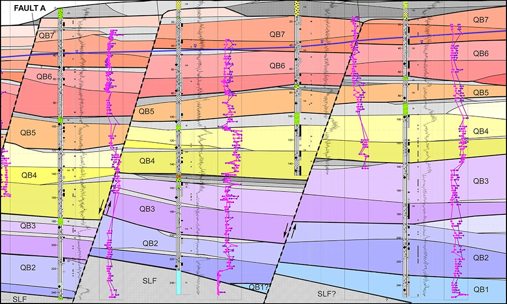
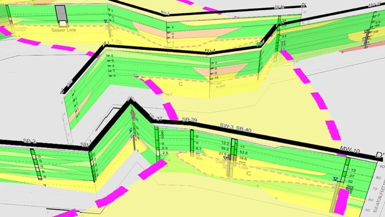
Hydrogeologic cross-section constructed from detailed rock core logs and high-resolution geophysical and geochemical data. We were able to correlate individual basalt flows and numerous sedimentary interbeds, which were offset by multiple normal faults.
What to know: Fully defining the architecture of the subsurface is essential for effective site remediation, but it’s notoriously difficult using traditional methods. When practitioners couple novel data collection and visualization methods with rigorous geological analysis, they can quickly achieve more accurate, efficient, and cost-effective solutions.
Whether they are designing foundations or assessing contaminated sites for cleanup, engineers and environmental scientists need to understand how geologic materials (unconsolidated sediment or fractured bedrock) are distributed beneath a site’s surface. Unfortunately, many environmental professionals have failed to grasp the importance of performing detailed geological analyses, partly because of the difficulties in collecting large amounts of data or their reliance on simplistic subsurface data correlation techniques.
As technical advancements enrich our understanding of subsurface geology, new data collection and visualization methods offer promising ways to make our work more accurate, efficient, and cost-effective. This article explores how some of these methods can enhance geotechnical, mining, water resources, and environmental projects.
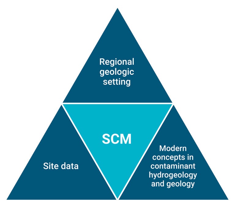
Understanding the three constraints on a site conceptual model (SCM) is crucial for effective site remediation.
Investing in data eliminates guesswork
Due to the absence of high-quality geologic data and analysis at many sites, faulty assumptions often lead to incorrect conclusions and ineffective — or even failed — remedial actions. Advanced geological analysis methods are a smarter way to proceed: Making early investments in high-quality data and rigorous geological analysis leads to success faster.
Coupling high-resolution site characterization with environmental sequence stratigraphy
At most environmental firms, geologists generally collect site data the same way their predecessors did: by drilling small-diameter borings or wells and removing soil or water samples for analysis. But advanced geological analysis techniques visualize subsurface conditions in novel ways, allowing unprecedented precision and efficiency.
In conventional subsurface investigations, data collection points are typically few and far between and are collected at rigid prespecified locations and intervals. High-resolution site characterization technologies concentrate data points in areas of particular interest in order to test and validate the subsurface geologic model developed by the project geologist.
The role of the project geologist is critical in this process. Even the most robust datasets provide only as much value as the inferences and insights a geologist derives from them. Environmental sequence stratigraphy (ESS) can improve these inferences and insights, allowing geologists trained in sedimentary geology (referred to as stratigraphers) to make accurate 3D models of the geology at and between the various measured data points. Stratigraphers initially develop these ESS geologic models as detailed 2D cross sections showing the geologic conditions at and between the borings. By extending these cross sections into 3D geologic models of the subsurface, stratigraphers can better convey the subsurface geologic conditions to both technical and nontechnical audiences. These models turn complex geologic data into a robust and understandable representation of the subsurface — one that is faithful to both the site data and the stratigrapher’s understanding of the depositional environment of the geologic materials.
These enhanced 3D ESS products accurately depict the subsurface geologic architecture through which groundwater and vapors flow. By providing hydrogeologists and engineers with a common visual language and medium, 3D geologic modeling streamlines collaboration and improves both environmental and geotechnical work products. ESS also facilitates the efficient refinement of robust site conceptual models throughout the project’s duration, not just during the initial stage. If a model reveals anomalies or inconsistencies, the project team can quickly collect and incorporate new data into the model, improving its accuracy and reliability.
Haley & Aldrich demonstrated that a buried stream channel functioned as the pathway for contaminants to migrate onto our client’s property.
When are advanced geological analysis methods appropriate?
When conventional methods have yielded inconclusive or insufficient data, advanced geological analyses can help determine whether, and why, contamination occurs at a particular site. For example, a Haley & Aldrich team determined that a gasoline spill at an upgradient property caused the soil and groundwater contamination at one of our clients’ industrial sites. At another site, we showed that a benign, naturally occurring lithium deposit — not an industrial release — was the source of lithium detected in groundwater, even though two previous site characterization efforts had been inconclusive. In both cases, we were able to prove that our clients were not liable, which helped them get reimbursed for their past remediation costs.
Still, descriptors like “high-resolution,” “enhanced,” and “advanced” belie the fact that the key ingredient in these approaches is as old-school as it gets: rigorous geological analysis. High-resolution subsurface data have no inherent value unless and until a trained geologist interprets them. When a trained geologist is on the job, the quality of interpretation improves by orders of magnitude with the quality of the subsurface data — in turn informing better decision making, improving the likelihood of success, and decreasing the probability that trial and error will strain budgets and stretch timelines.
Haley & Aldrich’s clients have experienced these benefits firsthand. By identifying data gaps, concentrating resources in areas of need, and continually refining our understanding of the subsurface conditions, we have brought stalled site cleanup efforts across the finish line in a single field season — including at one Superfund site where cleanup efforts had been stalled for more than a decade. In other words, coupled with rigorous geologic knowledge, these adaptable and iterative methods add efficiency to any project. Use them as needed.
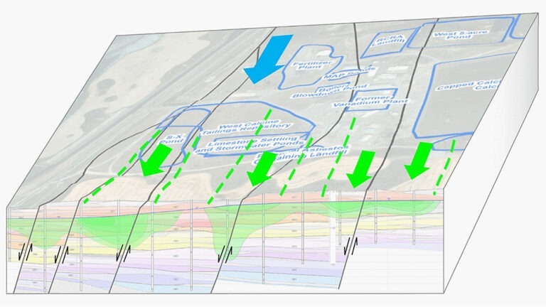
High-resolution technologies and advanced mineralogical analyses enabled the correlation of geologic layers that control contaminant migration in the subsurface, which facilitated the development of innovative in situ remedies designed to treat dissolved contaminants as they migrate through groundwater.

Published: 10/3/2025
Authors

Service Leader, Contaminated Site Management

Technical Expert, Geologist

Technical Expert, Environmental and Water Resources Engineer